
Google Maps Labs is a testing ground for experimental features that aren't quite ready for primetime. They may change, break or disappear at any time.
If such a feature breaks, and you're having trouble loading Maps, use this escape hatch:http://maps.google.co.in/maps?ftr=0.
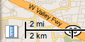 Distance Measurement ToolAdam S, Andrey S, James M, Seth LMeasure the distance of a path on the Earth
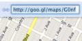 Short URLBen A, Holly DShorten the Maps "Link" to be a more compact URL.
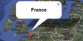
 Show Me Here!Cornelius QAdds an option to the context menu that lets you zoom directly to the maximum zoom level at the point under the cursor.
 Drag 'n' ZoomDave DZooming in on a specific part of the map is now fast and easy. Simply click the Drag 'n' Zoom button, draw a box on the map and zoom! You're there!
 Aerial ImageryJez F, Dave D, Jennifer CAdd Aerial imagery to the map! Aerial imagery gives you rotatable, high-resolution overhead imagery presented in a new perspective. Currently, imagery is only available in certain areas, but we're adding more all the time.
 Back to BetaDavid SGoogle Mail isn't the only one that can enjoy a BETA tag.
 Where in the World GameJez FTest your knowledge of world geography! Guess the name of the country from satellite imagery and try to beat your top score!
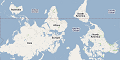 Rotatable MapsCornelius QTired of North always being up? Add rotatable map types and give East, West and South a fair go.
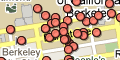 What's Around Here?Michael AAdds a button that displays the most-popular places in the current map view. A great way to browse the map.
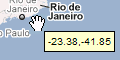 LatLng Tool TipMarcelo CDisplays a tool tip next to the mouse cursor, showing the latlng directly underneath it.
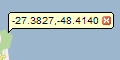 LatLng MarkerMarcelo CAdds an option to the context menu that lets you drop a mini-marker showing the latlng of the position at which the cursor was pointing when the context menu was evoked
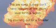 Smart ZoomJez FEver zoom in too far and get the message "We don't have imagery at this zoom level"? Ensure that you don't see it again, with Smart Zoom, which will check in advance what imagery exists and ensure that you can't zoom in beyond it.
Bonjour,
ReplyDeletePetit problème avec "OUTIL DISTANCE"
Lorsque je suis connecté sur mon compte, l'outil de mesure distance n’apparaît pas sur la carte.
Lorsque je me déconnecte de mon compte, l'outil réapparaît ???
Mon navigateur est Google Chrome 18.
Le problème est le même avec IE9
Cordialement.